Storm dumps rain on a soaked region
Published 7:27 am Wednesday, March 23, 2011

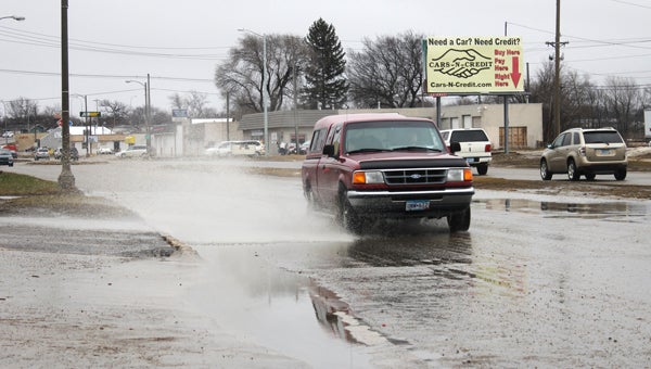
A Ford Ranger splashes through a puddle Tuesday afternoon on East Main Street near Hanson Tire Service. -- Tim Engstrom/Albert Lea Tribune
Spring isn’t all flowers and sunshine. It is thunderstorms and saturated basements, too.
Albert Lea residents were reminded of that last night when a thunderstorm struck the area after normal work hours and lasting to just about after bedtime for most folks.
Southwest Middle School recorded 2 inches of rainfall on Tuesday, according to Tribune weather partner KIMT. The Albert Lea Wastewater Treatment plant recorded two-thirds of an inch. The automated weather station at Albert Lea Municipal Airport, however, was unable to take a precipitation recording, possibly due to the freezing rain.
KIMT chief meteorologist Adam Frederick said it is likely that the storm delivered spotty rainfall amounts through the area.
While the thunder and lightning went away, the precipitation did not. People of northern Freeborn County reported snow on the ground this morning. Albert Lea mostly received freezing rain and sleet, with just a dash of snow around 5 a.m.
Snow indeed was in the Albert Lea forecast for Wednesday, with daytime temperatures expected to drop to 26 around 5 p.m.
Then there is the flooding aspect. The National Weather Service extended a flood warning Tuesday morning to include the Albert Lea area.
Much of southern Minnesota and parts of northern Iowa are under flood warnings issued by various bureaus of the National Weather Service. The Mankato area and other susceptible places along rivers had been in flood warnings already.
Rain and melting snow caused waters to rise Tuesday and today, resulting in floods and runoff. Several creeks and streams across the region already are out of their banks.
Emergency management officials report the following rivers out of their banks: Redwood, Cottonwood, Little Cottonwood, Watonwan, Rush, Cannon and Straight.
Minnesota counties under flood warnings Tuesday were Martin, Freeborn, Faribault, Watonwan, Steele, Waseca, Blue Earth, Nicollet, Brown, Rice, Le Sueur, Redwood, Goodhue, Sibley, Mower, Lac qui Parle, Yellow Medicine, Lyon, Jackson, Cottonwood, Chippewa, Kandiyohi, Meeker, McLeod, Wright, Carver, Hennepin, Ramsey, Washington, Scott, Dakota and Wright.
Iowa counties under flood warnings Tuesday were Worth, Cerro Gordo, Mitchell, Floyd, Butler, Bremer, Black Hawk, Kossuth, Humboldt, Emmet, Dickinson, Clay, Buena Vista, Lyon, Sioux and Plymouth.
Winnebago County, Iowa, is not in the flood warning. However, one Lake Mills resident tells the Tribune she has flooding in her basement.
The flood warning for the Albert Lea area is in effect until 3:30 p.m. today. Some roadways are covered with water. The Minnesota Department of Transportation this morning closed East Main Street at Clark Street — usually the city’s first sign of high water. The street will be closed until further notice.
The Minnesota Department of Transportation says roads in southern Minnesota are in fair condition — not good, but fair — and cautions drivers to watch for icy patches.
In Ramsey County, officials prepared for the Mississippi River to hit historic levels. Flood preparations turned tragic Tuesday when a Minnesota Department of Transportation backhoe operator clearing debris from a culvert lost control and plunged into the Minnesota River between St. Peter and Mankato. The worker who was presumed dead was 39-year-old Michael Struck of Cleveland.
Near Austin, Turtle Creek reached 10.9 feet on Sunday night. On Monday, it dropped back below flood stage of 10.5 feet, according to a hydrological monitor. It rose again Tuesday night over flood stage, reaching 11.6 feet around 7 a.m. today. It is expected to crest around 11.9 feet today. The creek dumps into the Cedar River in Austin and begins at Geneva Lake in Freeborn County.
The same storm system brought the white stuff to the Twin Cities and points northward. Roads were closed and schools were let out.
Interstate 94 westbound was shut down for a time between Highways 52 and 61 near St. Paul because of a jackknifed semi. The National Weather Service issued a winter storm warning for portions of central Minnesota. Forecasters were expecting 4 to 8 inches of snow across the Twin Cities metro area.
The Albert Lea forecast for Thursday calls for a high in the 30s with partly cloudy skies.


